|
|
|
|
|
Click on image to enlarge. 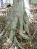
| |||||||||||||||||||||||||||||||||||||||||||||||||||||||||||||||||||||||||||||||||||||||||||||||||||||||||||||||
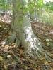
| Scientific name: : : : : Common Name: Information Sheet, Lawrence Kelleher Country: USA Photographer: E. M. Barrows Identifier: E. M. Barrows Abstract The aim of this study was to determine if there is a correlation between root
exposure of American Beeches and the slope of the land on which the trees
reside. Root exposure is an indication of erosion of soil from around tree
bases. The study of 20 trees demonstrated that a correlation exists between
these variables. For every 1° increase in slope, there is a 5.4 cm increase in
the amount of root exposed. Introduction The objective of my study is to determine if there is a relationship between
root exposure of American Beeches, in Glover-Archbold Park (GAP), and the slope
of the land on which they are located. The exposure of the roots indicates that
erosion has taken place, and may be used as a measure of erosion. Due to the
large amount of rainfall throughout 2003, I hypothesized that there is a
significant amount of the root exposure, thereby indicating that erosion has
taken place. However, I was not able to tell when the erosion had occurred, and
the erosion could have occurred in previous years. Also, I hypothesize that the
slope of the ground on which the tree is located is positively correlated with
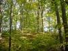
its down-slope root exposure. Glover-Archbold Park is a "finger park" of Rock Creek Park (Barrows
2003). It is composed of one major stream, the Foundry Branch, and can be
considered an urban forest. Neighborhoods and buildings surround GAP, yet it is
still home to a variety of wildlife. One of the major tree species in the GAP is
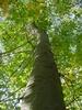
the American Beech. In this investigation, I studied the American Beech because of its prominence
in GAP. It is easily recognizable by its smooth gray branches and trunk. Its
leaves are alternate, simple, and serrated. According to Barrows (2002), the
versatile American Beech can live in a variety of habitats including closed
forests, successional areas, and forest exteriors, and its habit differs with
location. The American Beech plays several key roles in forests. Its hollow
trunks provide shelter for different forest organisms. Also, American Beeches
are food of organisms such as a moth species, a weevil species, and White-tailed
Deer. Erosion is the detachment of soil and sediments by hydrological (fluvial)
processes and the action of the wind (U.S. Global Change Information Office
2003). Erosion can be very devastating to a habitat. It reduces the amount of
nutrients that are available to plants and can reduce the diversity and
abundance of soil organisms. Erosion can be used as a good indicator of the
health of an ecosystem, and erosion estimates are significant to the issues of
land and water management. It is important to recognize that soil erosion can also occur through the
actions of Humans. The building of communities around an ecosystem, such as GAP,
is "human intervention." Humans probably increased the erosion in GAP
when they felled its large trees during the Civil War, and we are still
increasing its erosion by flooding Foundry Branch with precipitation runoff. Materials and Methods I collected data in both the northern and southern areas of GAP in October
and November 2003. The southern area as the region of GAP that lies south of
Reservoir Road, and the northern portion, north of this Road. I sampled the 20
trees non-randomly in these areas, 10 from each area. I chose American Beeches
of different ages and sizes. I chose them non-randomly from various locations
throughout GAP. The slopes on which sample trees grew varied greatly. After the trees were selected, I measured the length of the longest exposed
root in centimeters. Also I measured the slope of the land on which the tree was
located. In order to do this, I used a level and two poles. The slope was
calculated using geometry after two measurements were taken (the distance of
root exposure for a tree’s base and the vertical distance from point of
greatest root exposure to the baseline of a tree’s trunk). I used the level to
determine the plane of the baseline to enable correct measurements. I considered
the amount of root exposed to be an indication of the amount of erosion that has
taken place; the longer the exposed root, the greater the amount of erosion. Results and Discussion Twenty trees had a mean of 114.2 cm (3.4 – 402.3 cm) root exposure (Table
1). The average slope on which trees grew was 26.1° (1.9 – 72.4°) . Length of root exposure is positively correlated with slope of the ground
(Figure 1). There is a slight increase in the amount of exposed root as the
slope of the ground increases. Two of the datum points do not follow the general
trend. These are the root exposures that occur at 14.3° and 34.6°. This
variation may be due to the fact that these trees are located in an area where
there is an above average amount of erosion that is taking place. The slope of the best-fit regression line (Figure 1) indicates the increase
in the amount of root exposure verses land angle. The slope of the line is
approximately 5.43, indicating that there is a 5.43 cm increase in root exposure
for every 1° increase in slope. There is a significant correlation between
length of exposed roots and downward slope of the bank on which a tree is
growing (linear regression, r2 = 0.883, P < 0.001). Twenty
trees was an adequate sample to find the correlation. A fault of this study is that the trees were not chosen in a randomly and the
data may therefore be biased. In future studies, a random number table should be
used so the study sites are picked in a randomly. This would help to ensure that
the data are not skewed based on a particular factor in the area of the Park
where most of the trees were studied. However, I did chose a sample of trees
that are growing an a large range of slope angles. This study will make it possible to perform future studies that can compare
the amount of erosion that takes place from year to year. It is possible that
the data used in this experiment can be used as a basis to see if further
erosion is taking place. Also, it may be important to try to correlate the
health of a tree to the amount of erosion that has taken place. The study would
be much more relevant if it were conducted throughout the entirety of GAP rather
than in just small sections of northern and southern GAP. Due to time restrictions, I was unable to determine if there was a
correlation between the amount of exposed root of a tree and how long it stands
before it falls due to erosion. It is important for future studies to observe
this so as to inform National Park Service (NPS) about erosion and tree falls. Acknowledgements I thank Dr. E. M. Barrows for supplying me with the necessary equipment and
guidance throughout the course of this investigation. I would also like to thank
Matthew J. Fanelli, my research partner, for venturing into the woods with me
and aiding me with my more difficult measurements. Literature Cited Barrows, E. M. 2002. Information Sheet, American Beech. Internet file. http://biodiversity.georgetown.edu/searchfiles/infosearch.cfm?view=all&IDNumber=1444 (15 December 2003) Barrows, E. M. 2003. Information Sheet, Glover-Archbold Park, Washington, D.C.
Internet file. U.S. Global Change Information Office. 2003. Soil and sediment erosion. Internet file. http://www.gcrio.org/geo/soil.html (15 December 2003)
|
|||||||||||||||||||||||||||||||||||||||||||||||||||||||||||||||||||||||||||||||||||||||||||||||||||||||||||||||
